Hiking in Japan: Most Scenic Japanese Hiking Trails
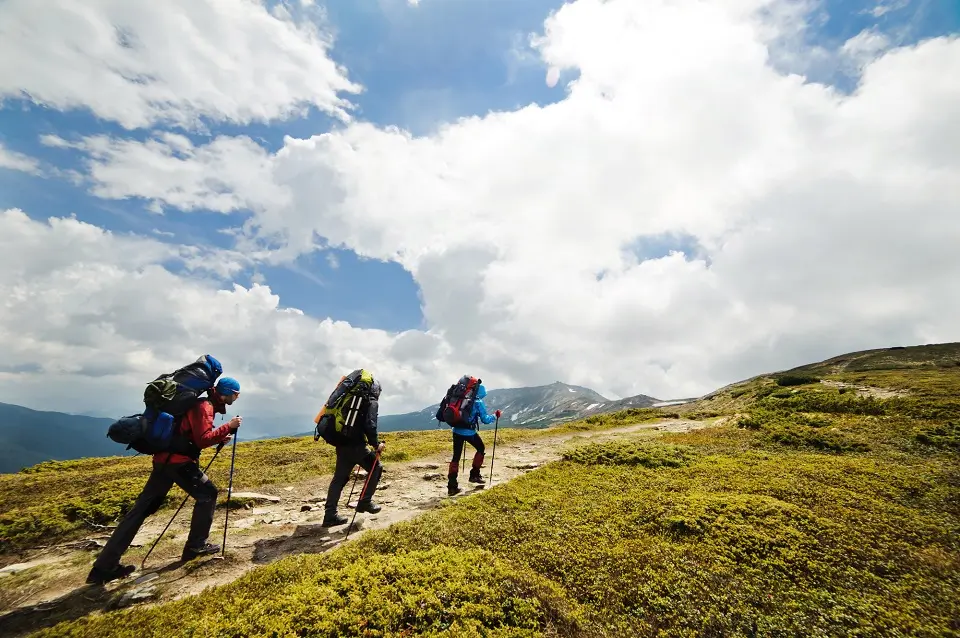
Foreigners who have only been to Tokyo may not realize that Japan is a paradise for outdoor activities like hiking and trekking. This article will discuss some of the best places for hiking in Japan and the best Japanese hiking trails.
An archipelago of stunning contrasts, Japan seamlessly blends millennia-old traditions with modern marvels. Yet, beyond the neon-lit metropolises and ancient shrines, the country’s natural wonders and scenic hiking trails offer breathtaking experiences for hikers and outdoor enthusiasts to explore.
Embarking on a journey through Japan’s extraordinary hiking trails is a foray into nature’s beauty and communion with the nation’s cultural heart. Each step taken on these trails reveals Japan’s topographical diversity and weaves a story of its history, spirituality, and enduring love for nature. Among many lesser-known tourist spots in Japan, these hiking trails are the best areas to explore Japan’s natural beauty.
Whether it’s scaling Mount Fuji’s iconic heights, treading the Kumano Kodo’s historical paths, or discovering the enchanting scenery of the Nakasendo route, hiking in Japan promises a rewarding escapade of both physical exertion and spiritual fulfillment.
Following are some of the most popular scenic hiking trails in Japan. However, to travel to some of these remote places from major cities of Japan, you may also like to know about Japanese transportation:
Hiking in Kumano Kodo (Kansai)

The Kumano Kodo is a network of ancient pilgrimage routes that traverse the Kii Peninsula in Japan. These routes lead to three sacred sites: the Kumano Hongu Taisha, Kumano Nachi Taisha, and Kumano Hayatama Taisha. Collectively, these are known as the Kumano Sanzan. The Kumano Kodo provides unforgettable hiking and trekking experiences.
About Kumano Kodo
This network of pilgrimage trails is located in the Kii Peninsula in the southern part of the Kansai region. The trails span across three prefectures: Wakayama, Nara, and Mie. The three grand shrines of Kumano, known as Kumano Sanzan (Kumano Hongu Taisha, Kumano Nachi Taisha, and Kumano Hayatama Taisha), are key destinations on the routes.
For over a thousand years, all sorts of pilgrims have used the routes—from emperors and aristocrats to commoners. They’re also a UNESCO World Heritage site, part of the “Sacred Sites and Pilgrimage Routes in the Kii Mountain Range” property.
The Kumano Kodo offers scenic beauty with its mountainous landscapes, lush forests, waterfalls, rivers, and quaint villages. It’s a spiritual experience and an opportunity to immerse yourself in nature and Japan’s rich history.
Hiking Routes
The hiking trails consist of several routes, the most popular of which are the Nakahechi route, the Kohechi route, and the Iseji route. Each has a different length and difficulty level, from multi-day treks to day trips.
- Nakahechi Route: This route is the most traveled by international visitors. Starting from the town of Tanabe on the western coast of the Kii Peninsula, it takes two or three days to reach the grand shrine at Hongu, followed by another two days to reach Nachi Taisha and Hayatama Taisha. The trail is well-marked, and there are numerous villages along the way where you can rest, eat, and sleep.
- Kohechi Route: This challenging, mountainous route connects the sacred sites of Koyasan and the Kumano Sanzan. It’s a long, four-day trek that requires good physical fitness and careful planning, as there are few places to rest or resupply.
- Iseji Route: This is the longest route, traveling along the eastern coast of the Kii Peninsula. It is moderately more difficult than the Kohechi route, but it takes about a week to complete.
Accommodation and Facilities
Along the routes, there are various options for accommodation, ranging from family-run Minshuku (B&Bs), and Ryokan (traditional Japanese inns) to modern hotels. You’ll also find rest stops, toilet facilities, and vending machines at certain points along the hiking trails.
Best time for the Hike
The best time for hiking in Kumano Kodo is in spring (March to May) and autumn (September to November) when temperatures are mild and the scenery is most beautiful. Avoid the summer if you’re not accustomed to hot and humid conditions, and winter can be cold and sometimes snowy.
Before You Go
- Planning: Due to its popularity, booking accommodation in advance is recommended, especially during peak seasons. The Tanabe City Kumano Tourism Bureau offers a free reservation service that can be used to book accommodations along the hiking trail.
- Packing: Pack as lightly as possible, but carry essentials like a good map, a compass, adequate clothing, rain gear, and snacks. Some services can forward your luggage to your next destination, allowing you to hike with a day pack.
- Fitness Level: Evaluate your fitness level before choosing a hiking route. Some routes are quite strenuous, with steep climbs and descents, while others suit less experienced hikers.
- Guidance: Guided tours are available, and they can provide additional insight into the history and cultural significance of the sites along the trail.
Not Just Hiking but a Spiritual Journey
Finally, remember that the Kumano Kodo is not just a hiking trail but a spiritual journey that pilgrims have undertaken for centuries. Respect the sanctity of the trail and the environment by staying on the marked paths and observing local customs and rules. Leave no trace, pack out what you pack in, and ensure your visit doesn’t disrupt the tranquility and purity of this sacred place.
A journey along the Kumano Kodo offers a unique experience to immerse yourself in the natural beauty of Japan, the warmth of its people, and its rich cultural heritage. Whether you’re a history buff, a nature lover, or a spiritual seeker, the Kumano Kodo has something for everyone. It’s not just about the destination; the journey itself is equally significant and enriching.
It’s important to remember that while the Kumano Kodo is a fantastic experience, it can be physically challenging. Good preparation, appropriate equipment, and respect for the trails and the environment are crucial to enjoying this unique journey. Always check the latest information and prepare for weather conditions to ensure a safe and enjoyable trip.
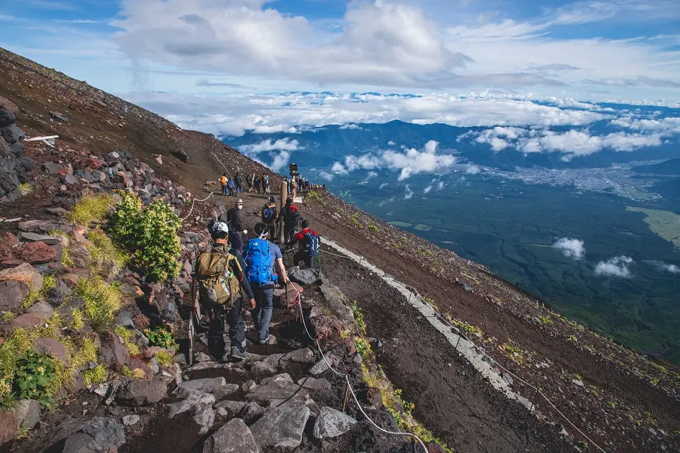
Climbing Mount Fuji (Shizuoka and Yamanashi)
This iconic mountain is situated on the island of Honshu, Japan’s main island. It’s located in the Chubu region, straddling the boundary between Shizuoka and Yamanashi prefectures. Mount Fuji is approximately 100 kilometers southwest of Tokyo, making it visible on the city’s horizon on clear days.
Significance and Overview
Mount Fuji is Japan’s highest mountain, standing at 3,776 meters (12,389 ft). This iconic peak is one of Japan’s “Three Holy Mountains,” along with Mount Tate and Mount Haku. It’s also a UNESCO World Heritage site, a source of artistic inspiration and religious pilgrimage for centuries.
The Climbing Experience
Climbing Mount Fuji is strenuous and requires physical fitness and preparation. The hike is steep, and the air becomes thin at higher altitudes, making breathing difficult. But the challenge is often considered worth it for the stunning sunrise view from the summit, a sight known as “Goraiko,” meaning “honorable arrival of light.”
Climbing Seasons
The official climbing season for Mount Fuji is from early July to early September. The mountain huts are open during this time, and medical aid stations are operating. For the rest of the year, climbing is highly discouraged due to severe weather conditions, the risk of snow and ice, and the absence of support facilities.
Climbing Routes
There are four major routes to the summit of Mount Fuji: Yoshida, Subashiri, Gotemba, and Fujinomiya. All these routes have ten stations, with the first station at the base and the tenth at the summit. However, most climbers start at the fifth station, which is accessible by road.
- Yoshida Trail: This is the most popular route due to its many mountain huts and facilities. It starts at the Fuji-Subaru Line 5th Station and has separate paths for ascent and descent.
- Subashiri Trail: This trail also starts from the 5th station but is on the mountain’s east side. The ascent and descent paths are the same until they join the Yoshida trail at the 8th station.
- Gotemba Trail: This is the longest and least developed route, with fewer mountain huts and facilities. It’s also the lowest of the fifth stations, which means more climbing and fewer crowds.
- Fujinomiya Trail: The Fujinomiya 5th station is the closest to the summit, making it the shortest route. However, it is steep and does not offer different trails for ascent and descent.
Accommodation
Mountain huts (or ‘Goya’) are available along the routes approximately from the 7th station onward. These provide basic accommodation with meals but need to be booked in advance during the climbing season.
Summit and Descent
The summit has several features to explore, including a crater, a weather station, and the Kusushi Shrine. The descent can be more challenging due to the loose volcanic rock, which can be slippery.
Specific Guidelines for Climbing Mount Fuji
- Physical Preparation: Although common, it’s important to emphasize the physical demands of the hike. Altitude sickness is a real concern and can affect anyone, regardless of fitness level.
- Timing the Climb: Many hikers time their climb to witness the sunrise at the summit. This typically involves climbing to a mountain hut to rest before continuing the hike very early in the morning.
- Packing Essentials: In addition to common hiking gear, carry a headlamp (for a night climb), hiking poles (for the descent), and Japanese yen (as the huts and facilities do not accept cards). The weather can be unpredictable and get quite cold at the summit, even in the summer, so warm clothing and rain gear are necessary.
- Safety Measures: Remember that weather conditions can change quickly. Always check the weather forecast before climbing, and be prepared to turn back if conditions become unsafe. It is advisable to descend immediately if you begin to experience symptoms of altitude sickness, such as dizziness, nausea, headaches, or shortness of breath.
- Preservation of the Environment: As with any natural site, following a “leave no trace” policy is essential. Bring all your trash back down the mountain with you, stay on the designated trails, and respect the mountain’s cultural and religious significance.
Guided Tours to Mount Fuji
Although it’s possible to climb Mount Fuji without a guide, beginners and less experienced climbers might consider booking a guided tour. A guide can provide safety, local knowledge, and assistance with logistics.
Mount Fuji isn’t just a mountain; it’s a symbol of Japan. The challenge of the climb, the spiritual significance of the peak, and the sublime beauty of the view from the top all contribute to a unique and unforgettable hiking experience. As with any challenging outdoor adventure, preparation is the key to a safe and enjoyable trip.
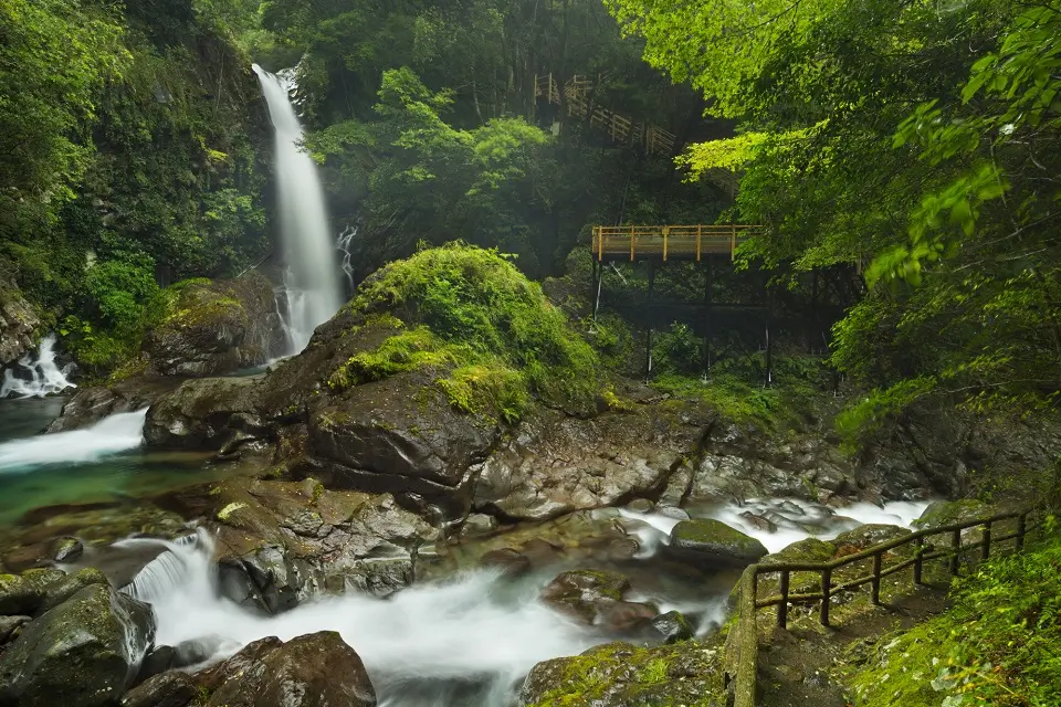
Hiking in Izu Peninsula (Shizuoka)
About Izu Peninsula:
- Location and Overview: The Izu Peninsula is in Shizuoka Prefecture, central Japan, about 100 kilometers southwest of Tokyo. It is known for its scenic beauty, hot springs, and proximity to the Pacific Ocean.
- Significance: The peninsula’s geographical features range from mountainous regions in the center to stunning coastlines. Its uniqueness stems from the region’s geological activity. It is part of the “Ring of Fire,” which offers beautiful landscapes, hot springs, and opportunities for various outdoor activities.
- The Hiking Experience: The Izu Peninsula offers a variety of hiking trails suitable for different fitness levels. These trails allow you to immerse yourself in nature, passing through beautiful coastal views, lush green landscapes, volcanic formations, and abundant hot springs.
Details about Hiking in the Izu Peninsula
- Hiking Trails: The peninsula’s trails range from leisurely walks along the coast to more challenging mountain hikes. Some popular hiking trails include the Mount Omuro hike, the Jogasaki Coast hike, and the trails around Kawazu Seven Waterfalls.
- Attractions: Key attractions include the stunning coastal views along the Jogasaki Coast, panoramic vistas from the top of Mount Omuro, and the serene atmosphere around Kawazu Seven Waterfalls. Apart from natural beauty, the peninsula also offers cultural experiences like the Shuzenji Temple and numerous onsen towns like Atami, Ito, and Shuzenji.
Specific Guidelines about Hike
- Best Time to Visit: The peninsula is a year-round destination due to the mild climate. However, the hiking experience can be more enjoyable during the spring (cherry blossom season) and autumn (fall colors).
- Transportation: You can reach the Izu Peninsula by train or bus from Tokyo. The Izu Kyūkō Line connects most of the peninsula’s eastern and southern coasts.
- Facilities: There are various accommodations, from luxury resorts to budget guesthouses, particularly in the onsen towns.
- Precautions: Weather can change quickly in the region, so check the local forecast before heading out. Stay on designated trails to protect the environment and ensure safety.
The Izu Peninsula offers diverse landscapes and experiences, making it an excellent choice for nature lovers, hot spring enthusiasts, and hikers. With its mix of sea, mountains, and rich cultural heritage, it provides a refreshing getaway from the hustle and bustle of city life.
Hiking on Nakasendo Hiking Trail
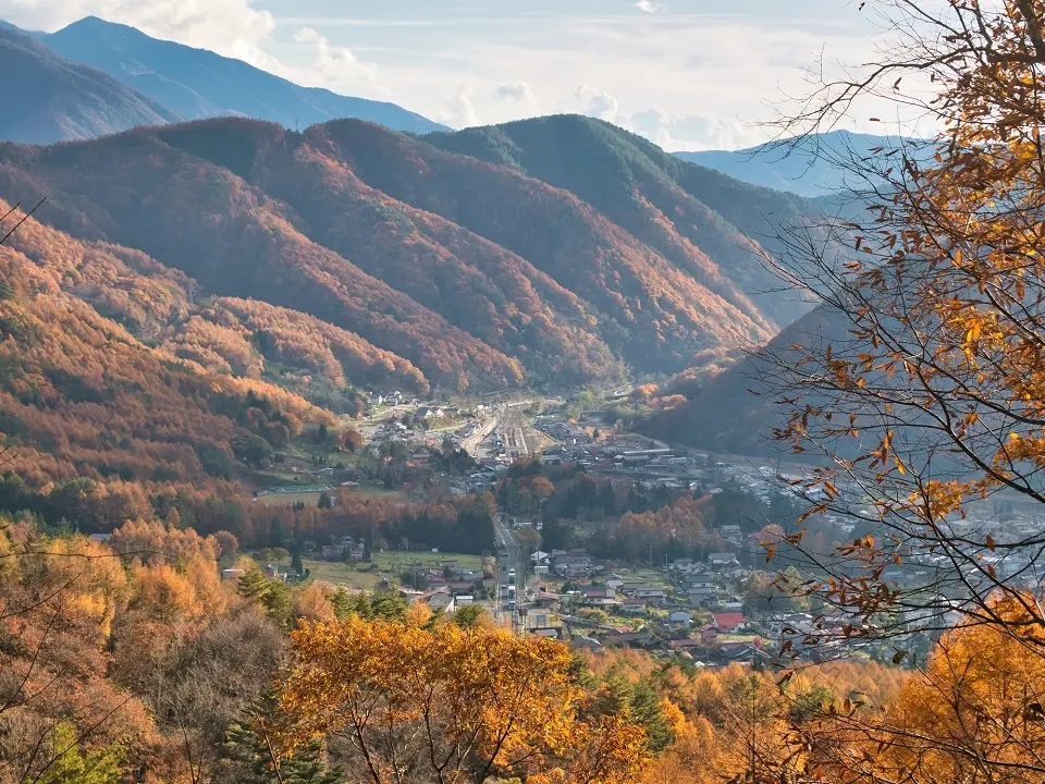
Also known as the “Central Mountain Route,” the Nakasendo trail connected Edo (modern-day Tokyo) to Kyoto during the Edo Period. The path runs through the central part of Honshu, passing through several modern-day prefectures, including Saitama, Gunma, Nagano, Gifu, and Shiga.
About Nakasendo:
- Significance and Overview: The Nakasendo (which means “central mountain route”) is one of the five routes of the Edo period that connected Edo (modern-day Tokyo) to Kyoto. Unlike the more coastal Tokaido route, the Nakasendo takes an inland path, allowing you to experience the scenic beauty of Japan’s central mountains.
- The Hiking Experience: The complete Nakasendo is approximately 534 kilometers (332 miles) long and contains 69 post towns, which were stops providing rest and refreshments for travelers in the Edo period. Today, hiking the Nakasendo offers a glimpse into Japan’s past, with its preserved post towns, historical sites, and scenic landscapes.
- Best Sections to Hike: The entire route takes weeks to cover on foot, and parts of it now overlap with modern roads and railways. As a result, most hikers choose to walk specific sections. The most popular and well-preserved is the Kiso Valley section, which includes the post towns of Magome, Tsumago, and Narai. This portion provides a beautiful and convenient hike with a well-marked trail, historical attractions, and charming accommodations.
Specific Inputs for Hiking in Nakasendo
- Trail Difficulty: The difficulty level of the Nakasendo is generally moderate. It’s not a strenuous mountain climb but a leisurely hike with some hills. The paths are well-maintained and suitable for hikers of various skill levels.
- Timing and Season: While the Nakasendo can technically be hiked year-round, the best times are generally in the spring (for the cherry blossoms) and autumn (for the fall foliage). The Kiso Valley section between Magome and Tsumago is around 8 km and can be comfortably completed in about 2-3 hours.
- Accommodation and Dining: The post towns along the trail offer a range of accommodations, including Minshuku (family-run guesthouses), Ryokan (traditional inns), and hotels. Many of these provide meals featuring local cuisine. Some towns, like Narai, also have small shops and restaurants for daytime visitors.
- Attractions: Beyond the scenic trails, there are several attractions along the Nakasendo. The towns of Magome and Tsumago are beautifully preserved, with traditional wooden buildings, stone paths, and watermills. Both towns also offer museums detailing the area’s history. Narai, known as “Narai of a Thousand Houses,” is the longest post town and features numerous historic buildings.
- Transportation: Many of the post towns are easily accessible by public transportation, making it convenient to hike various parts of the trail. For example, hiking the Magome to Tsumago trail can start from either end, with buses available to take you back to your starting town.
Nakasendo: Tips for Hiking
- Maps and Signage: While the Nakasendo is generally well-signed, having a map is always a good idea. Some sections of the trail can get confusing, especially where it intersects with local roads.
- Packing Essentials: Pack light, but be sure to carry water, snacks, and weather-appropriate clothing. Also, consider carrying a small bell or other noise-making devices – the sound can help deter any bears that might be in the area.
The Nakasendo offers a unique hiking experience where history, nature, and culture intertwine. Walking this historic route allows you to step back in time and enjoy the slower pace of traditional Japan.
Hiking in Shirakawa-go and Gokayama (Gifu and Toyama)
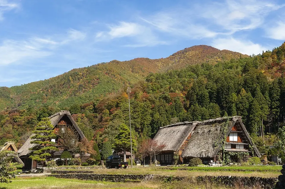
These historic villages are located in the mountainous region that spans from Gifu to Toyama Prefectures in the Chubu region of central Japan. Specifically, Shirakawa-go sits in the Shogawa River valley in Gifu Prefecture, and Gokayama is located in the northern part of Toyama Prefecture. These areas are known for their heavy winter snowfall.
About Shirakawa-go and Gokayama
- Significance and Overview: Located in the remote mountains that span from Gifu to Toyama Prefectures, Shirakawa-go, and Gokayama are UNESCO World Heritage Sites known for their traditional gassho-zukuri thatched-roof farmhouses, some of which are more than 250 years old. The architectural style is characterized by a steeply slanting thatched roof designed to withstand the heavy snow that the region receives in winter.
- The Village Experience: While not traditional hiking destinations in the same sense as trails or mountains, these villages offer unique exploration. Walking around, you’ll see the historic farmhouses, rice fields, and beautiful surroundings. The areas are particularly scenic in winter when the houses are covered in snow and in spring when the cherry blossoms are in bloom.
Specific Inputs for Hiking in Shirakawa-go and Gokayama:
- Visitor Paths and Observation Points: There are walking paths throughout both areas, allowing visitors to admire the farmhouses up close. In Shirakawa-go, an observation point on a hill overlooking the village provides a fantastic view of the entire area.
- Farmhouses and Museums: Many of the farmhouses are open to the public. In Shirakawa-go, the Wada House, a designated Important Cultural Property, provides a look at a typical home, while the Nagase House serves as a museum. In Gokayama, the Ainokura Folklore Museum and the Suganuma Gassho-style Hamlet (a cluster of 9 gassho-zukuri farmhouses) are must-see spots.
- Workshops: Gokayama is famous for its traditional washi paper, and you can participate in washi-making workshops at the Gokayama Washi-no-Sato.
Tips for Exploring Shirakawa-go and Gokayama
- Timing Your Visit: While these villages can be visited year-round, they offer different experiences depending on the season. Winter brings beautiful snowscapes, spring offers lovely blossoms, summer provides lush greenery, and autumn is filled with colorful foliage. Note that winter visits can be challenging due to heavy snowfall and cold temperatures.
- Getting Around: Both areas are compact enough to explore on foot. Shuttle buses in Shirakawa-go can take you to the observation point. Be aware that the paths can be steep and slippery, particularly in wet or snowy conditions.
- Accommodation: To fully experience the area’s atmosphere, consider staying overnight in a Minshuku (family-run bed and breakfast) in one of the traditional houses. Advanced booking is advised, especially in peak seasons.
- Respecting the Area: These are living villages where people still reside, so remember to respect private property and local customs.
Visiting Shirakawa-go and Gokayama offers a journey into Japan’s rural and cultural heritage. Rather than a physical challenge, the experience here is about immersion, discovery, and a step back in time to traditional Japanese life.
Hiking in Yakushima Island (Kagoshima, Kyushu)
About Yakushima Island
- Location and Overview: Yakushima is a subtropical island off the southern coast of Kyushu, the third largest island of Japan’s main islands. It’s part of Kagoshima Prefecture, located approximately 135 kilometers south of the Osumi Peninsula.
- Significance: Yakushima is a UNESCO World Heritage Site, famous for its lush vegetation and ancient cedar forests, some of which are believed to be over 7,000 years old. The island is often associated with “Jomon Sugi,” an enormous cedar tree that’s estimated to be between 2,170 and 7,200 years old, making it one of the oldest trees in the world.
- The Hiking Experience: With its diverse ecosystem, rugged mountains, and primeval forests, Yakushima is a paradise for nature lovers and hikers. The island offers numerous hiking trails for all skill levels, from leisurely coastal walks to challenging mountain treks.
Specific Inputs about Hiking in Yakushima Island
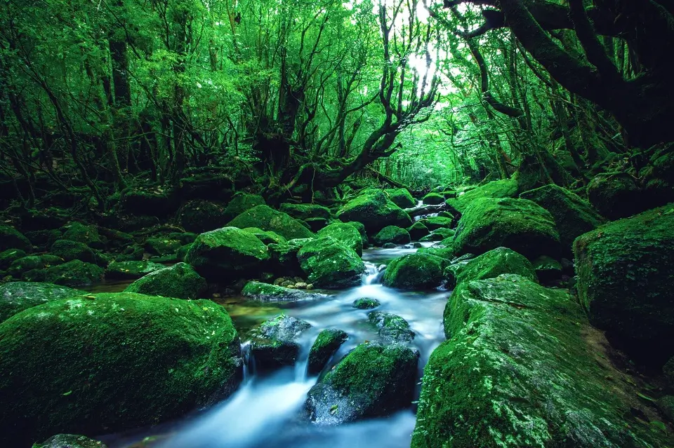
Hiking Trails: There’s a variety of trails in Yakushima, the most famous being the trail to Jomon Sugi. This route is approximately 22 kilometers round trip and takes around 9-10 hours to complete. It’s a strenuous hike, but the sight of the famous Jomon Sugi, a 7,000-year-old cedar tree, is worth the effort. Other notable trails include the Shiratani Unsuikyo trail, where you can experience the island’s mossy forests that inspired the Studio Ghibli film “Princess Mononoke,” and the Yakusugi Land trail, a nature park filled with ancient cedars.
Wildlife: Yakushima is home to diverse wildlife, including endemic Yakushika deer and Yakuzaru monkeys. Bird watchers will also appreciate the many species found here.
Climate and Weather: Yakushima is known for its rainy climate; it’s often said that it rains “35 days a month” on the island. This abundant rainfall contributes to the island’s lush vegetation. Be prepared for wet conditions, especially in the more mountainous interior.
Tips for Hiking Yakushima Island
- Time and Season: The best time to hike in Yakushima for hiking is from April to November. Winter can be challenging due to snowfall in the mountains. Remember that the Jomon Sugi hike is a full-day outing, and starting early is advisable.
- Park Entry and Rules: As a national park and a UNESCO World Heritage Site, Yakushima has rules for visitors. These include prohibitions on removing plants or animals, making loud noises, and camping or making fires outside of designated areas.
- Stay on the Trail: The island’s ecosystem is delicate, and hikers should stick to the marked trails to avoid damaging the vegetation or disturbing the wildlife.
- Prepare for Wet Weather: Given Yakushima’s climate, waterproof gear is essential. This includes waterproof hiking boots, rainwear, and waterproof cases for electronics.
Yakushima offers an extraordinary hiking experience full of natural beauty and unique ecological encounters. The island’s ancient cedars, diverse wildlife, and rich vegetation make it a truly stand-out destination.
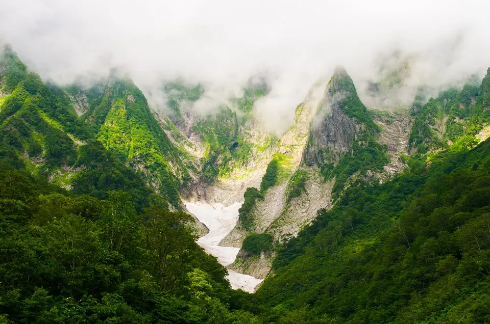
Hiking in Kamikochi (Nagano)
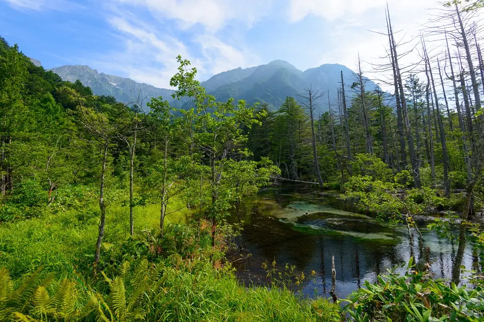
About Kamikochi
- Location and Overview: Kamikochi is a remote mountainous highland in the western portion of Nagano Prefecture, situated in the northern Japan Alps. It’s part of the Chūbu-Sangaku National Park and represents one of the country’s most scenic spots.
- Significance: Kamikochi is renowned for its natural beauty, featuring pristine rivers, verdant forests, and towering mountain peaks. The area’s altitude varies from 1,500 meters at the valley floor to over 3,000 meters at the mountain peaks.
- The Hiking Experience: Kamikochi is a hiker’s paradise, offering trails for all experience levels. Hikers can enjoy leisurely walks along the Azusa River, moderate hikes to destinations like Myojin Pond, or challenging mountain climbs to the summits of the surrounding peaks.
Specific Inputs for Hiking in Kamikochi
- Hiking Trails: Several trails cater to casual hikers and serious mountaineers alike. The Kappa Bridge, at the center of Kamikochi, serves as a starting point for most trails. From there, one popular route follows the Azusa River to Myojin Bridge and Myojin Pond, which takes about 2-3 hours round trip. More experienced hikers might attempt the day-long hike to the top of Mt. Yake, an active volcano, or the multi-day traverse of the “Japan Alps” along the Yarigatake and Hotaka mountain ranges.
- Wildlife and Flora: Kamikochi is rich in flora and fauna. It’s home to monkeys, various bird species, and the elusive Kamoshika (Japanese Serow), a goat-antelope native to Japan. The diverse plant life changes with the seasons, providing beautiful views year-round.
- Scenic Spots: There are several must-see spots in Kamikochi. The Kappa Bridge offers a panoramic view of the highland. Taisho Pond, where dead trees jut out from the mirror-like water, offers a unique landscape, especially during sunrise. Myojin Pond is a sacred spot with a small shrine on its banks.
Tips for Hiking in Kamikochi
- Season and Timing: Kamikochi is usually accessible from late April until mid-November. Outside of these months, the area is closed due to heavy snowfall. July and August are the busiest months, while fall brings stunning autumn foliage.
- Prepare for Changes in Weather: Even in the summer, temperatures can drop significantly, especially at night, so it’s essential to pack appropriately. Sudden weather changes can occur, so be prepared for possible rain and cooler temperatures, even on a sunny day.
- Respect Nature: Camping is only allowed in designated campsites to protect the area’s natural beauty, and open fires are prohibited. Ensure you carry all the trash, as there are no garbage bins in the park.
- Transportation: Kamikochi is a car-free zone, so access is only possible via bus or taxi. Buses run from Matsumoto, Takayama, and other nearby towns.
Kamikochi is a breathtaking destination, offering a tranquil escape into nature and a range of outdoor activities. From its serene ponds and clear rivers to the imposing peaks of the Japan Alps, it provides a memorable hiking experience.
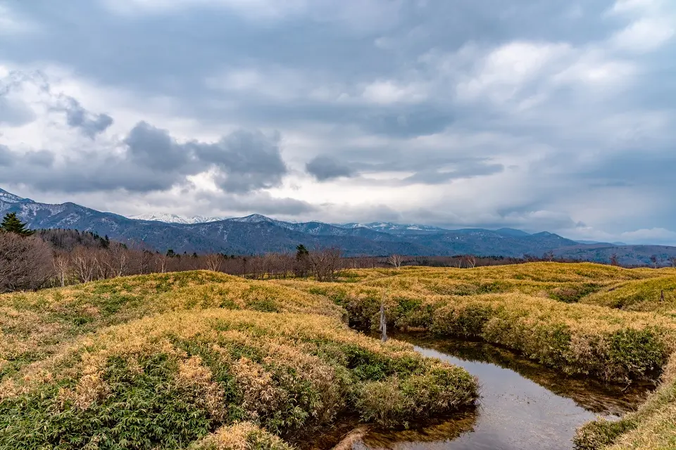
Hiking in Daisetsuzan National Park (Hokkaido)
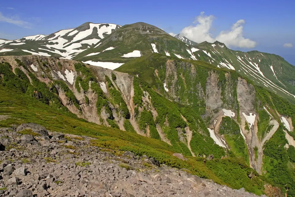
About Daisetsuzan National Park
- Location and Overview: Daisetsuzan National Park is located in the central part of Hokkaido, Japan’s northernmost island. It’s the largest national park in Japan, covering over 2,267 square kilometers. The name Daisetsuzan translates to “Great Snowy Mountains,” fittingly describing its rugged and mountainous terrain.
- Significance: The park is home to some of Hokkaido’s highest mountains, including Mount Asahi, the tallest in Hokkaido, and numerous others surpassing 2,000 meters. Daisetsuzan is well-known for its pristine wilderness, diverse wildlife, and natural hot springs (onsen).
- The Hiking Experience: Daisetsuzan National Park is a dream destination for hikers and outdoor enthusiasts. It offers a multitude of hiking routes, ranging from easy walks to challenging multi-day treks. The park is full of volcanic landscapes, alpine vegetation, and stunning panoramic views.
Specific Inputs for Hiking in Daisetsuzan National Park
- Hiking Trails: Popular hiking routes include the Asahidake to Kurodake traverse, a challenging but rewarding trail that takes you across some of the park’s highest peaks. The Ginsendai to Sounkyo hike is a less strenuous option, yet it provides equally impressive views. There are also shorter trails available for less experienced hikers, such as the circular hiking trail around the Sugatami Pond at the base of Mount Asahi.
- Flora and Fauna: The park is home to a rich variety of wildlife, including brown bears (known as Higuma), sika deer, and various bird species. As for the plant life, Daisetsuzan is famous for its alpine flowers, which bloom from June to August, and the autumn colors in September are a sight to behold.
- Mountain Huts and Onsen: Daisetsuzan has several mountain huts that can provide accommodation for multi-day treks. After a long day of hiking, nothing beats a soak in one of the park’s many natural onsens.
Tips for Hiking in Daisetsuzan National Park
- Best Time to Hike: The hiking season in Daisetsuzan typically runs from late June until early October. However, the weather can change rapidly in the park, especially at higher altitudes, so it’s necessary to come prepared for all conditions.
- Prepare for Wildlife Encounters: Since brown bears are found in the park, hikers are advised to make noise while hiking to avoid surprising them. Bear bells are commonly used for this purpose.
- Respect the Environment: As in all national parks, respecting the natural environment is essential. Stick to the trails, don’t feed the wildlife, and carry out all trash.
Daisetsuzan National Park offers an authentic wilderness experience with its dramatic landscapes, diverse flora and fauna, and unique thermal hot springs. Hiking here can be a powerful way to connect with nature and experience the beauty of Hokkaido’s outdoors.
Hiking in Iya Valley (Tokushima, Shikoku)
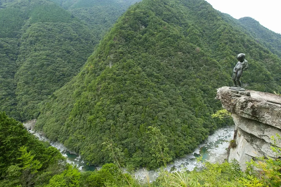
About Iya Valley
- Location and Overview: The Iya Valley is located in the mountainous interior of Shikoku, the smallest of Japan’s four main islands. It’s part of Tokushima Prefecture and is known for its steep, forested gorges and tranquil, rural atmosphere.
- Significance: Iya Valley, often referred to as one of Japan’s “three hidden regions,” is famous for its stunning natural beauty, historic vine bridges, and traditional thatched-roof farmhouses. It provides a look into the old, rural side of Japan that’s far removed from the bustling cityscapes.
- The Hiking Experience: Hiking in the Iya Valley offers a variety of outdoor experiences, from gentle walks along the river to more challenging mountain trails. The area’s remote, serene atmosphere makes it an ideal destination for hikers seeking a peaceful immersion in nature.
Specific Inputs for Hiking in Iya Valley
- Hiking Trails: One of the most popular trails leads to Mt. Tsurugi, the second-highest peak on Shikoku and one of Japan’s top 100 mountains. The hike takes you through beautiful forested terrain and offers spectacular views from the summit. Another trail follows the scenic Iya River, taking hikers past the vine bridges and through small, traditional villages.
- Historic Vine Bridges: Among the valley’s main attractions are its kazura-bashi (vine bridges). Originally built by the Heike clan, these bridges were a part of the region’s defenses, allowing warriors to cut down the bridges to prevent pursuers from following. Today, the remaining bridges are maintained for tourists and offer a unique hiking experience.
- Scenic Beauty: The valley is characterized by steep cliffs, lush vegetation, clear streams, and hot springs. The scenic beauty changes with the seasons, offering various shades of greens in spring and summer, colorful foliage in autumn, and a snowy wonderland in winter.
Tips for Hiking Iya Valley
- Best Time to Visit: Iya Valley can be visited year-round, but spring (April to June) and fall (October to November) are considered the best times to hike due to the mild temperatures and beautiful scenery. Fall foliage, in particular, can be quite stunning.
- Prepare for Remote Conditions: While the valley has seen increased tourism in recent years, it still remains a remote region. Facilities can be sparse, especially on the trails, so it’s important to bring everything you need with you, including food and water, maps, and a first-aid kit.
- Pay Attention to Safety Signs: Pay attention to signs and guidelines, especially at vine bridges and along mountain trails. Some parts of the trails can be steep and challenging, requiring good physical fitness.
Iya Valley provides an off-the-beaten-path experience of Japan with its unspoiled nature, historic sites, and peaceful rural atmosphere. It’s an excellent choice for hikers seeking a quiet escape and an immersive experience in traditional Japanese culture.
Hiking in Tateyama Kurobe Alpine Route (Toyama and Nagano)
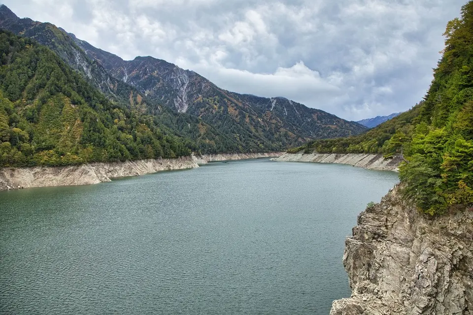
About Tateyama Kurobe Alpine Route
- Location and Overview: The Tateyama Kurobe Alpine Route is a spectacular scenic route running through the Northern Japan Alps in the Chubu Region. It connects Toyama City in Toyama Prefecture with Omachi Town in Nagano Prefecture.
- Significance: The Alpine Route is internationally renowned for its stunning vistas of the Northern Japan Alps, its extensive array of alpine flora and fauna, and the Kurobe Dam, Japan’s tallest at 186 meters.
- The Hiking Experience: The route offers a variety of hiking opportunities, from short, leisurely walks to challenging mountain treks. Whether you’re a casual walker or an experienced mountaineer, you’re sure to find a trail that suits your level.
Specific Inputs for Hiking in Tateyama Kurobe Alpine Route
- Hiking Trails: There are numerous trails along the route, each offering unique experiences. The trek between Murodo and Daikanbo, passing by Mikurigaike Pond, is a popular day hike. Mount Tateyama, one of Japan’s “Three Holy Mountains,” presents a challenging climb for seasoned hikers, while the walk across the Kurobe Dam offers breathtaking views and a less strenuous option.
- Snow Corridor: One of the most famous features of the Alpine Route is the Snow Corridor, where walls of snow reach heights of up to 20 meters in the spring. It’s usually open to pedestrians from mid-April to mid-June.
- Flora and Fauna: The area is home to a diverse range of alpine plants and wildlife. Depending on the season, you can see various species of flowers in bloom and animals such as rock ptarmigans, mountain antelopes, and Japanese snow monkeys.
Tip for Hiking in Tateyama Kurobe Alpine Route
- Season and Timing: The Alpine Route is open from mid-April to late November. The snow corridor can be experienced in the spring, while summer brings comfortable hiking weather and colorful alpine flowers. Autumn offers vibrant fall foliage, typically peaking in late September to early October.
- Altitude Sickness: Some points of the route, such as Murodo, are at high altitudes (2,450 meters). If you’re planning to hike in these areas, it’s essential to be aware of the symptoms of altitude sickness and take time to acclimatize.
- Transportation: The Alpine Route involves various modes of transportation, including cable cars, trolley buses, and a ropeway. It’s a one-way route, so you’ll need to plan your itinerary and timings accordingly.
The Tateyama Kurobe Alpine Route offers a unique and awe-inspiring journey through one of Japan’s most beautiful mountain landscapes. With its blend of natural beauty and impressive artificial structures, it’s a must-visit destination for any hiking enthusiast.
Hiking in Mount Yari (Gifu)
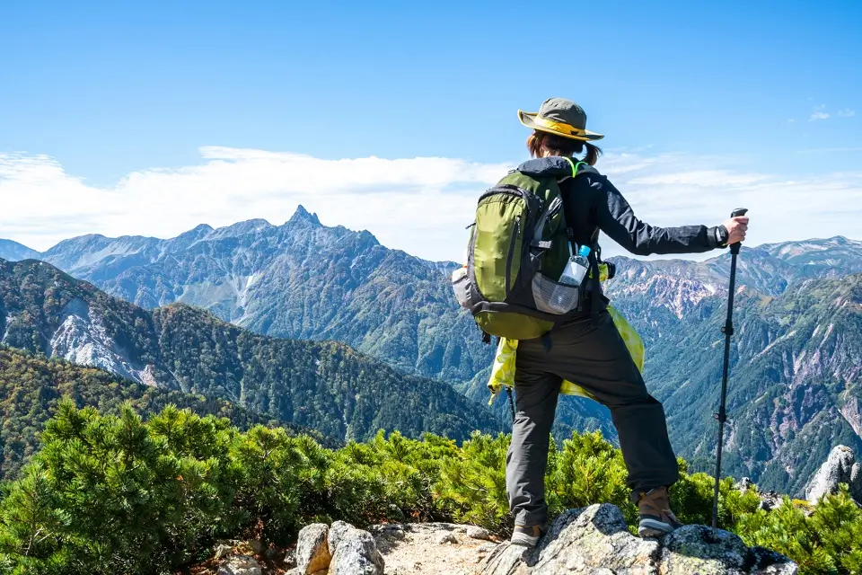
About Mount Yari
- Location and Overview: Mount Yari (Yarigatake) is located in the Northern Japan Alps in the Gifu Prefecture, Japan. Its peak stands at 3,180 meters, making it one of the tallest mountains in Japan. The mountain is a part of the Chūbu-Sangaku National Park.
- Significance: Mount Yari is popular among hikers due to its striking spear-like shape, hence the name Yari, which means “spear” in Japanese. The mountain is part of the “100 Famous Japanese Mountains” list and is a common destination for climbers and outdoor enthusiasts.
- The Hiking Experience: Mount Yari offers various trails of different difficulty levels. The journey to its peak is a thrilling challenge, with steep climbs and stunning views of the surrounding peaks and valleys.
Specific Inputs for Hiking in Mount Yari
- Hiking Trails: There are several routes to the summit of Mount Yari, with the most popular ones starting from Kamikōchi or Shin-Hotaka Onsen. The ascent from Kamikōchi is longer but less steep, while the trail from Shin-Hotaka Onsen is shorter but more challenging. The trek usually takes two days, with an overnight stay at the Yarigatake Sanso mountain hut near the summit.
- Flora and Fauna: While hiking, you can enjoy the alpine vegetation and wildlife, with the chance to spot rock ptarmigans, a bird species typical in high mountain areas.
- Mountain Huts: Besides the Yarigatake Sanso near the summit, there are several mountain huts along the way where hikers can rest, eat, and sleep. However, you should make an advanced booking during the peak season.
Tips for Hiking in Mount Yari
- Best Time to Visit: Mount Yari’s hiking season typically runs from July to early October. Snow can be present outside this period, requiring mountaineering skills and equipment.
- Safety and Preparedness: The trails can be steep and challenging, so it’s important to wear sturdy hiking boots and bring hiking poles for extra stability. Given its high elevation, be aware of the symptoms of altitude sickness and acclimatize accordingly.
Mount Yari is a beautiful and rewarding challenge for experienced hikers. The mountain’s unique spear-like appearance, awe-inspiring views, and sense of accomplishment upon reaching the summit make it a memorable hiking destination in Japan.
Hiking in Shiretoko Peninsula (Hokkaido)
About Shiretoko Peninsula:
- Location and Overview: The Shiretoko Peninsula is in the northeastern part of Hokkaido, Japan’s northernmost island. The peninsula is remote and largely undeveloped, with much of its area only accessible by boat or on foot.
- Significance: Shiretoko is a UNESCO World Heritage site recognized for its extraordinary ecosystem. It’s home to a variety of wildlife, including brown bears, red foxes, and numerous bird species. The area also hosts the highest concentration of waterfalls in Japan.
- The Hiking Experience: The Shiretoko Peninsula provides a truly wild hiking experience with its untouched nature, diverse wildlife, and breathtaking landscapes of mountains, forests, and sea.
Specific Inputs for Hiking in Shiretoko Peninsula
- Hiking Trails: Shiretoko offers several trails of varying difficulty and length. Popular routes include the Shiretoko Goko Lakes area, an easy trail with wooden walkways and stunning lake views, and the trail to Furepe Waterfall. For more experienced hikers, the multi-day hike from Utoro to Rausu is a challenging trek across the peninsula’s interior with amazing views from Shiretoko Pass.
- Wildlife Watching: Shiretoko is one of the best places in Japan for wildlife viewing. Hikers should keep a respectful distance, especially from the brown bears. For safety reasons, hikers must join a group tour in some areas, such as the trail to Mount Rausu.
- Scenic Beauty: The peninsula offers awe-inspiring views of the Sea of Okhotsk, dramatic mountain ranges, serene forests, and stunning waterfalls.
Tips for Hiking in Shiretoko Peninsula
- Best Time to Visit: Shiretoko can be visited year-round, but the best time for hiking is from June to early November. Winter brings heavy snowfall, making many of the trails impassable.
- Be Prepared for Weather Changes: The weather in Shiretoko can change quickly, so having the appropriate gear is essential. Rain gear, warm clothing, and sturdy hiking boots are necessary.
- Respect Wildlife: Be aware of wildlife, particularly brown bears, and keep a safe distance. Bear bells or bear spray can be a good precaution.
Hiking in Shiretoko offers a unique opportunity to explore one of Japan’s wildest and most beautiful areas. Whether you’re an experienced hiker or a nature lover, the peninsula’s breathtaking scenery and diverse wildlife make it a rewarding destination.
Hiking in Oirase Gorge (Aomori)
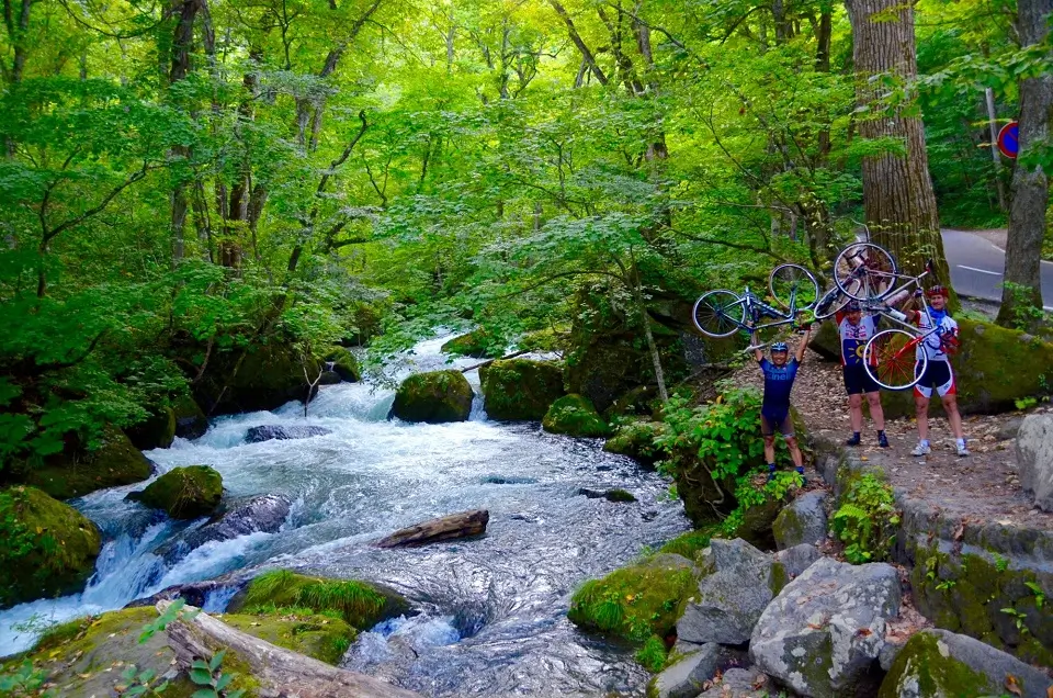
About Oirase Gorge
- Location and Overview: The Oirase Gorge is located in the Aomori Prefecture in the northern part of Honshu, Japan’s main island. It is the only outlet draining Lake Towada, a large double-caldera lake that flows along a beautiful forested stream for about 14 kilometers.
- Significance: Oirase Gorge is famous for its natural beauty. The stream, with a series of rapids and waterfalls, combined with the lush greenery of the forest, makes it a popular destination for nature lovers and photographers. It’s especially beautiful in autumn when the leaves change colors.
- The Hiking Experience: A well-maintained walking trail runs along the stream, offering an enjoyable and relatively easy hike suitable for hikers of all levels.
Specific Inputs for Hiking in Oirase Gorge
- Hiking Trail: The main trail in Oirase Gorge runs along the Oirase Stream from Nenokuchi on the shores of Lake Towada to Yakeyama. It takes around 4-5 hours to cover the entire 14 km length on foot. The trail offers views of various waterfalls, swift rapids, and quiet stream pools.
- Flora and Fauna: The forest around the Oirase Stream is primarily beech and Japanese hornbeam. You can see various species of birds in the gorge. And it’s a splendid place to enjoy koyo, the changing autumn leaves.
- Noteworthy Spots: Key points along the trail include the Kumoi-no-taki and Choshi-otaki Waterfalls. Another highlight is the Ashura Current, a particularly beautiful and rapid section of the stream.
Tips for Hiking in Oirase Gorge
- Best Time to Visit: You can visit Oirase Gorge throughout the year, but it is particularly breathtaking during the autumn leaf season (usually late October to early November). The area also offers beautiful green scenery in the spring and summer, and the frozen waterfalls in winter offer a unique spectacle.
- Transportation: Buses run along the road adjacent to the stream, so tired hikers can hop on a bus at various points along the trail.
- Safety Measures: The trail is well-maintained, but it’s always a good idea to wear sturdy footwear, and during colder months, warm, layered clothing is recommended.
Hiking in Oirase Gorge offers a great opportunity to immerse yourself in one of Japan’s picturesque natural landscapes. Its gentle trail, combined with the mesmerizing beauty of the stream and the surrounding forest, makes for a very pleasant hiking experience.
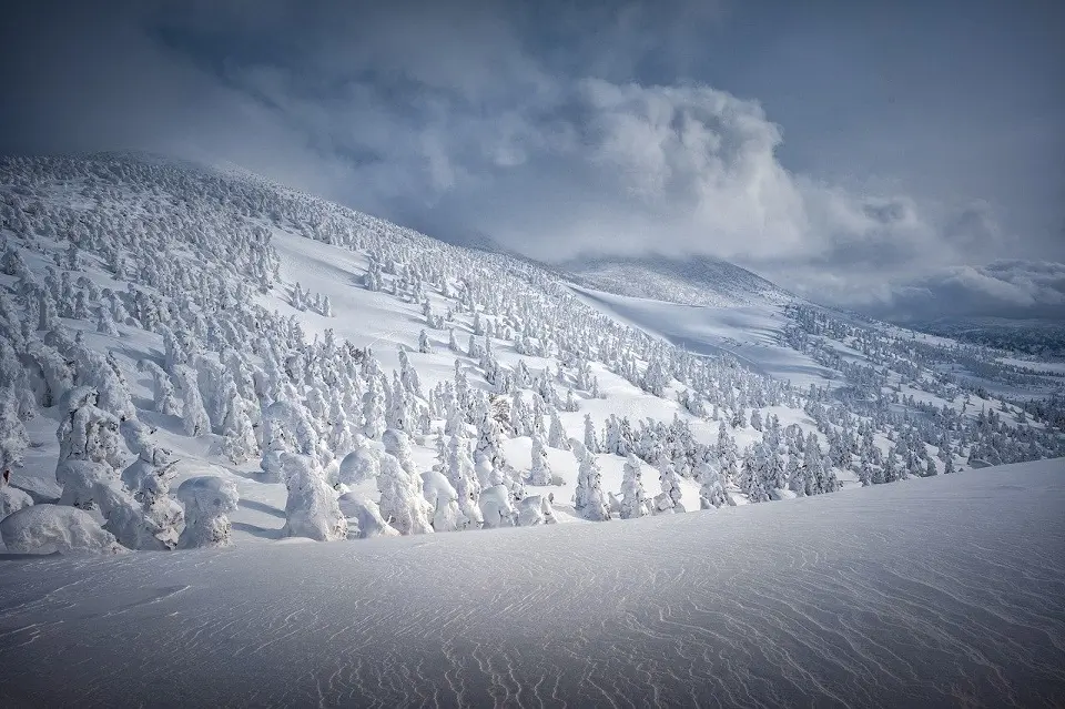
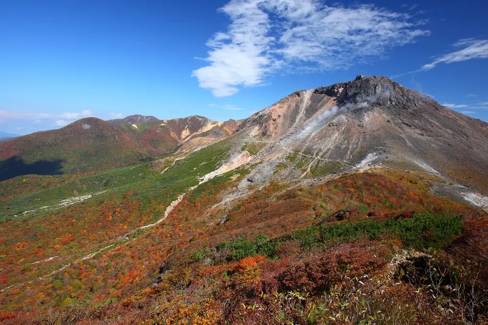
Hiking in Mount Zao (Miyagi and Yamagata)
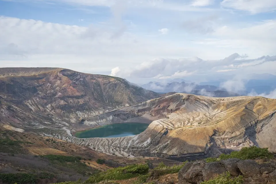
About Mount Zao
- Location and Overview: Mount Zao is a complex of volcanic mountains and crater lakes straddling the border between Miyagi and Yamagata Prefectures in the Tohoku region of Japan. It’s one of the most prominent mountains in the country, with the highest peak (Kumano-dake) standing at 1,841 meters (6,040 feet).
- Significance: Mount Zao is famous for its beautiful landscapes, hot springs, and skiing resorts. One of its most famous features is the Okama Crater, also known as the “Goshikinuma” (Five Color Pond), which changes color throughout the day depending on the light.
- The Hiking Experience: Hiking Mount Zao offers diverse experiences throughout the year, from vibrant autumn colors to frost-covered “snow monsters” in winter.
Specific Inputs for Hiking in Mount Zao
- Hiking Trails: There are several trails on Mount Zao of varying lengths and difficulties. The most popular hiking route starts at Zao Onsen, a hot spring town on the Yamagata side, and leads to the summit via the Zao Sky Cable and ropeway. This route offers beautiful views of the Okama Crater and the surrounding landscape.
- Flora and Fauna: Mount Zao’s vegetation changes with altitude, offering a variety of scenic landscapes. The area is also home to a variety of wildlife, including several bird species and small mammals.
- Mountain Huts and Facilities: On Mount Zao, there are a few mountain huts where hikers can rest and buy refreshments. Toilet facilities are also available at the Zao Ropeway stations.
Tips for Hiking in Mount Zao
- Best Time for Hiking The best times to hike Mount Zao are summer and autumn. Summer offers pleasant weather, while autumn offers stunning fall foliage.
- Weather and Clothing: Weather in mountainous areas can be unpredictable. Carry rain gear, wear sturdy hiking shoes, and dress in layers to adjust to changing conditions.
- Safety: Always stick to the designated trails, and be aware of volcanic gases around the crater areas.
Mount Zao offers an excellent hiking experience for those who wish to enjoy beautiful volcanic landscapes, stunning views, and the rejuvenating hot springs of Zao Onsen after a fulfilling day of hiking.
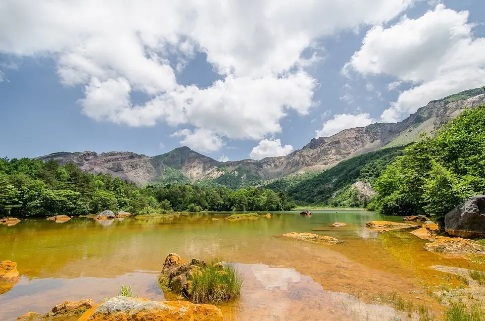
Hiking Around Nachi Falls and Kumano Nachi Taisha (Wakayama)
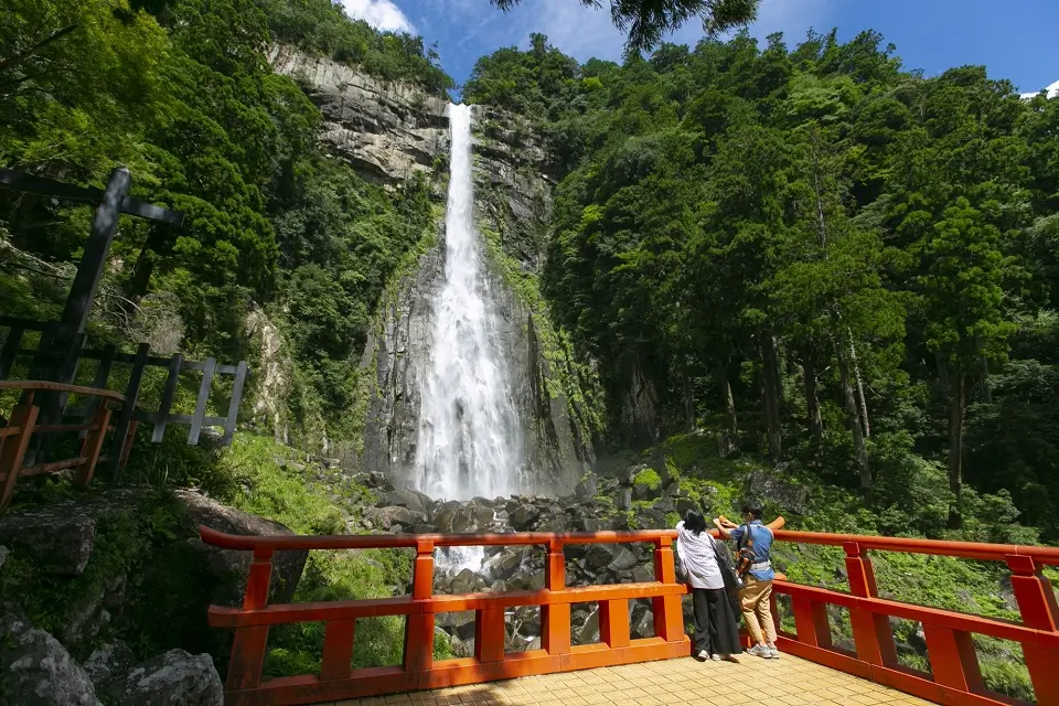
About Nachi Falls and Kumano Nachi Taisha
- Location and Overview: Nachi Falls and Kumano Nachi Taisha are located in the Kii Peninsula in the Wakayama Prefecture, Japan. Nachi Falls, known as Nachi-no-Taki in Japanese, is the tallest waterfall in Japan, with a single uninterrupted drop of 133 meters (436 feet). Kumano Nachi Taisha is one of the three grand shrines of the Kumano region and a key part of the UNESCO-designated World Heritage Kumano Kodo pilgrimage route.
- Significance: Nachi Falls is both a natural wonder and a sacred site. The shrine complex of Kumano Nachi Taisha is a spiritual place renowned for its striking vermilion-colored buildings set against the backdrop of the forested mountains.
- The Hiking Experience: The area offers hiking experiences imbued with natural beauty and spiritual significance. It’s an excellent opportunity to experience the ancient pilgrimage routes, sacred architecture, and Japan’s tallest waterfall.
Specific Inputs for Hiking around Nachi Falls and Kumano Nachi Taisha
- Hiking Trails: One of the popular hiking trails in this area is the Daimonzaka Trail, a section of the old Kumano Kodo pilgrimage route leading to Kumano Nachi Taisha. This paved cobblestone trail lined with ancient cedar trees offers a serene hiking experience.
- Attractions: Along the trail, you’ll come across the grand Kumano Nachi Taisha, Seigantoji Temple, and the three-story pagoda with Nachi Falls as its backdrop. You can also take a side trip to visit the Nachi Primeval Forest, a natural sanctuary surrounding the waterfall and shrine.
Tips for Hiking around Nachi Falls and Kumano Nachi Taisha
- Best Time to Visit: The area can be visited all year round. However, spring (March to May) with the cherry blossoms and autumn (September to November) with the fall colors provide especially scenic views.
- Cultural Etiquette: As Kumano Nachi Taisha is a religious site, you should show respect in and around the temple grounds. Dress modestly and follow any posted guidelines.
- Facilities: Although there are restaurants, shops, and restrooms around the shrine area. However, remember to carry water and snacks for the trail.
Hiking around Nachi Falls and Kumano Nachi Taisha offers a unique blend of natural beauty and cultural richness. It’s a journey that lets you enjoy the breathtaking landscape while delving into the spiritual heritage of the ancient Kumano Kodo pilgrimage route.
Hiking on Yamanobe-no-michi Trail (Nara)
About the Yamanobe-no-Michi Trail
- Location and Overview: The Yamanobe-no-michi Trail is in the Nara Prefecture, part of Japan’s Kansai region. The trail extends about 12 kilometers from Sakurai City in the south to Nara City in the north.
- Significance: Yamanobe-no-michi is part of the Shugendo spiritual tradition and is considered the oldest road in Japan, mentioned in the Nihon Shoki, the oldest chronicles of Japan. It’s more of a countryside trail rather than a mountain hike, providing a peaceful stroll along the eastern edge of the Nara Basin.
- The Hiking Experience: The trail offers a laid-back hiking experience with plenty of cultural and historical attractions, like ancient shrines and temples, traditional houses, and farmlands. It allows hikers to experience Japan’s rural scenery and traditional culture.
Specific Inputs for Hiking on amanobe-no-Michi Trail
- Hiking Trails: The trail follows a relatively flat path through farmlands, orchards, and small settlements. It’s a well-signposted trail marked by stone statues of deities known as “Dosojin.”
- Attractions: Some key attractions along the trail include the Omiwa Shrine, one of the oldest Shinto shrines in Japan; the Isonokami Jingu, an important shrine in ancient times; and the Yatogi Shrine, known for its ancient camphor tree. You’ll also pass by farmlands growing various fruits like strawberries, peaches, and persimmons that you can pick and eat in season.
Tips for Hiking on Yamanobe-no-Michi Trail
- Best Time to Visit: You can go hiking on the Yamanobe-no-Michi trail throughout the year. However, spring (for the cherry blossoms) and autumn (for the fall colors) offer especially beautiful views.
- Transportation: The trail is accessible by train. The southern trailhead at Omiwa Shrine is a short walk from Miwa Station, and the northern end is close to Kintetsu Nara Station.
- Facilities: Several shops and restaurants along the trail offer local food, like persimmon leaf sushi. Restrooms are also available at various points along the trail.
Walking along the Yamanobe-no-Michi trail is like stepping back in time. It’s an easy and pleasant walk that combines nature, history, and culture, offering a different kind of hiking experience compared to Japan’s more famous mountain trails.
Hiking in Mount Yoshino (Nara)
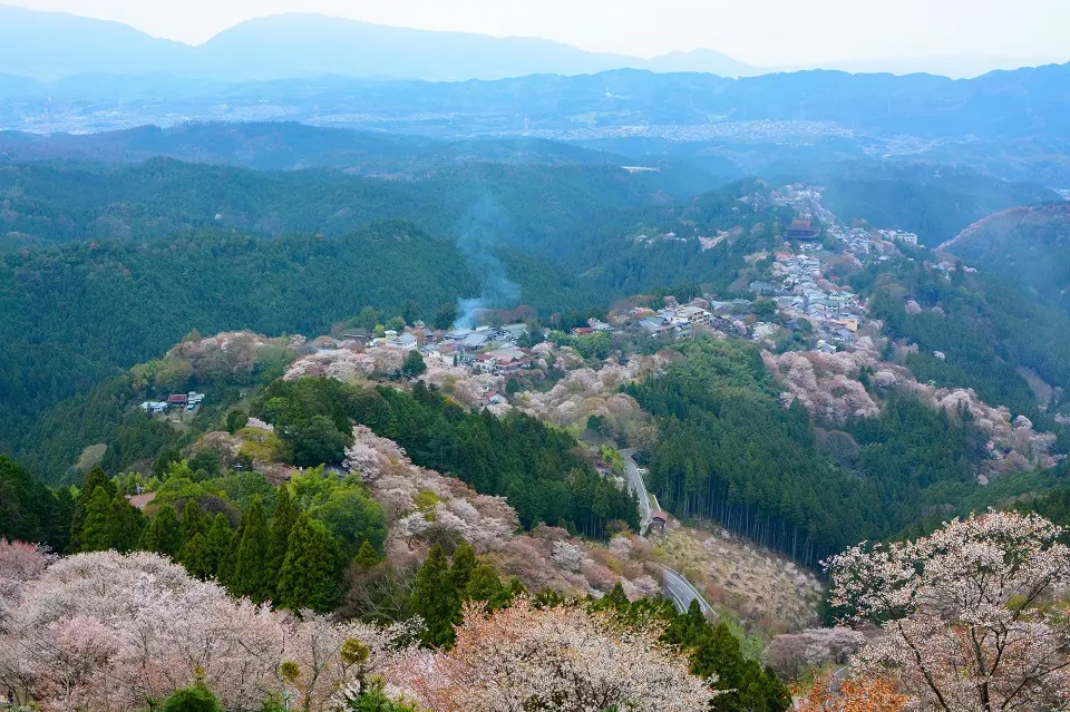
About Mount Yoshino
- Location and Overview: Mount Yoshino (Yoshinoyama) is located in the Nara Prefecture in Japan’s Kansai region. It’s a revered mountain known for its abundance of cherry trees, making it one of Japan’s most famous cherry blossom viewing spots.
- Significance: The mountain is significant not only for its natural beauty but also for its cultural and religious importance. It’s dotted with several temples and is part of the UNESCO World Heritage Sacred Sites and Pilgrimage Routes in the Kii Mountain Range.
- The Hiking Experience: Hiking on Mount Yoshino is tranquil and picturesque. The trails offer impressive views of the surrounding scenery, especially during the cherry blossom season when the mountain is blanketed in a sea of pink and white flowers.
Specific Inputs for Hiking in Mount Yoshino
- Hiking Trails: There are several walking trails on the mountain, meandering through the cherry tree groves and leading to various temples and lookout points. A popular trail takes you from Yoshino Station to the Yoshimizu Shrine, offering fantastic views of the cherry blossom-covered slopes.
- Attractions: Some of the key attractions on the mountain are the Yoshino Mikumari Shrine, an ancient Shinto shrine dedicated to water deities; the Kinpusenji Temple, the head temple of a branch of Shugendo mountain asceticism; and the Yoshimizu Shrine, known for its cherry blossoms and views over the valley.
Tips for Hiking in Mount Yoshino
- Best Time to Visit: The best time to visit Mount Yoshino is undoubtedly during the cherry blossom season, typically in early to mid-April. However, you will find heavy crowds during this time, so plan your visit accordingly.
- Transportation: Mount Yoshino is easily accessible by train. From Yoshino Station, visitors can walk up the mountain to the main sightseeing area.
- Facilities: There are numerous teahouses and restaurants on the mountain where visitors can enjoy a meal or snack. Restrooms are also available at various locations.
Mount Yoshino offers a delightful blend of natural beauty, cultural heritage, and spiritual significance. Whether you’re marveling at the cherry blossoms or exploring the numerous temples, hiking on Mount Yoshino is an experience that’s sure to leave a lasting impression.
Hiking in Mount Tarumae (Hokkaido)
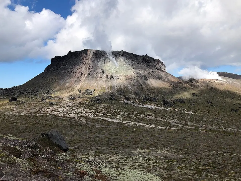
About Mount Tarumae
- Location and Overview: Mount Tarumae (Tarumaesan) is an active stratovolcano in Hokkaido, northern Japan island. It lies on the shores of Lake Shikotsu, within the Shikotsu-Toya National Park.
- Significance: It’s one of Japan’s most active volcanoes, with its last eruption in 1982. Despite this, its accessibility makes it a popular hiking destination.
- The Hiking Experience: Hiking Mount Tarumae offers a unique experience of venturing close to the summit of an active volcano. Its lunar-like landscape, formed from the hardened lava, starkly contrasts with the lush greenery at the mountain’s base.
Specific inputs for Hiking in Mount Tarumae
- Hiking Trails: One main trail leads up to the summit, with a well-trodden path and marker posts guiding the way. The trail begins from the 7th station car park, and it takes about 2-3 hours to reach the summit and return. The hike involves a steady incline but requires no technical climbing skills.
- Mountain Peak: The peak offers panoramic views of Lake Shikotsu and surrounding mountains. Moreover, you can also see the impressive lava dome from the most recent eruption.
Tips for Hiking in Mount Tarumae
- Best Time to Visit: The hiking season generally runs from late April to November. However, the conditions can vary greatly depending on the time of year, and the trail can be slippery after rainfall or in the early season when there’s still snow.
- Transportation: Accessing Mount Tarumae can be a bit tricky without a car because of limited public transportation. The closest bus stop is Tarumaezan Iriguchi, from where it’s a 3-kilometer walk to the trailhead.
- Facilities: Facilities are limited, with no mountain huts or toilets along the trail, so it’s recommended to come prepared with all necessary supplies.
Hiking Mount Tarumae is a thrilling experience. It gives hikers the rare opportunity to encounter an active volcano. Moreover, its unique landscapes and stunning views make it a worthwhile adventure for any hiking enthusiast.
Hiking in Mount Usu (Hokkaido)
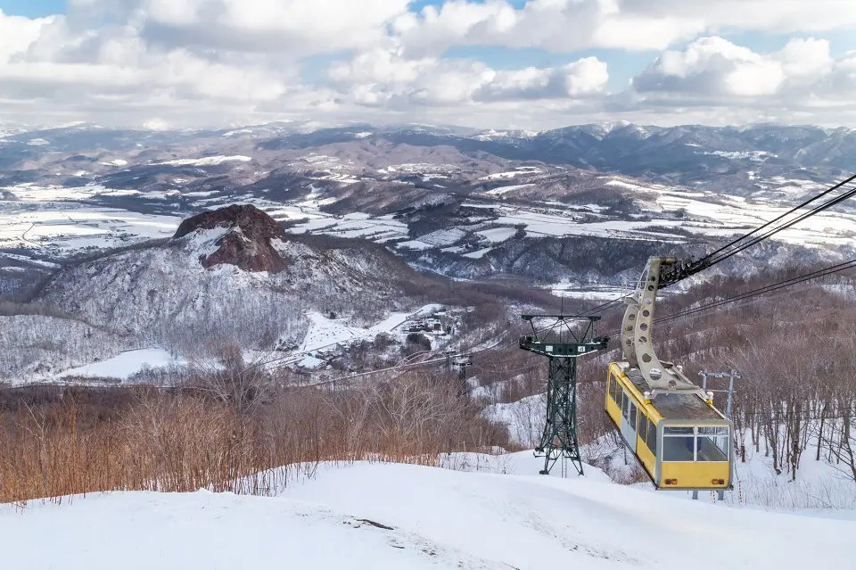
About Mount Usu:
- Location and Overview: Mount Usu (Usu-zan) is an active stratovolcano in the Shikotsu-Toya National Park in Hokkaido, the northernmost of Japan’s main islands. The mountain overlooks the picturesque Lake Toya.
- Significance: Known for its consistent volcanic activity, Mount Usu’s eruptions over the past century have provided valuable data for scientists studying volcanoes. Despite its activity, the mountain is a popular spot for tourists, offering a unique blend of natural beauty and geological intrigue.
- The Hiking Experience: Hiking Mount Usu offers a unique opportunity to observe active volcanic features up close, including several craters formed during the 20th-century eruptions.
Tips for Hiking in Mount Usu
- Hiking Trails: A popular hiking route is the Usu-zan Ropeway, which carries visitors halfway up the mountain. From the ropeway’s upper station, a well-maintained walking trail leads to several viewing points where you can observe the mountain’s volcanic activity and enjoy panoramic views of Lake Toya and Showa Shinzan, another nearby volcano.
- Attractions: Key attractions on Mount Usu include the craters from the 1943-1945 and 2000 eruptions, both accessible via walking trails. The Usu Volcano Memorial Park, located at the base of the mountain, houses a museum exhibiting volcanic rocks and information about Mount Usu’s eruptions.
Tips for Hiking in Mount Usu
- Best Time to Visit: You can visit Mount Usu throughout the year. However, due to Hokkaido’s snowy winters, hiking is most common from spring to autumn.
- Transportation: The mountain is accessible by car and public transportation. Buses run from Toya Station to the Usu-zan Ropeway.
- Facilities: The Usu-zan Ropeway’s lower and upper stations have restrooms and dining options. If you plan to spend significant time exploring the trails, it’s advisable to carry drinking water and snacks.
Thanks to its dynamic, ever-changing landscape, Mount Usu provides an unforgettable hiking experience. The stunning views and the chance to witness an active volcano up close make it a must-visit for any adventurer in Japan.
Hiking in Mount Hakkoda (Aomori)
About Mount Hakkoda
- Location and Overview: Mount Hakkoda is a volcanic mountain range consisting of multiple peaks in the southern part of Aomori Prefecture in the Tohoku region of Japan. It is within the borders of the Towada-Hachimantai National Park.
- Significance: Known for its stunning autumn colors, Mount Hakkoda is a popular destination for leaf peeping in the fall. In winter, it’s a well-regarded off-piste snowboarding and skiing destination.
- The Hiking Experience: Hiking in Mount Hakkoda offers a rich outdoor experience with its marshland, forests, and volcanic landscapes. It’s also famous for the “Hakkoda Death March,” a tragic event in 1902 in which 210 Imperial Japanese Army soldiers died in a blizzard during a military exercise.
Specific Inputs for Hiking in Mount Hakkoda
- Hiking Trails: There are multiple trails with different difficulty levels that can be explored in Mount Hakkoda. Some trails lead you to the marshland of Suiren Numa, while others take you to various peaks offering magnificent views.
- Mountain Peak: Odake is the highest peak, at 1585 meters. On clear days, it offers panoramic views of the surrounding areas, including the Pacific Ocean and Hokkaido.
Tips for Hiking in Mount Hakkoda
- Best Time to Visit: You can visit Mount Hakkoda year-round, but for hikers, the best time to visit would be from late spring to early autumn. The mountain is famous for its beautiful fall foliage, which usually peaks in early to mid-October.
- Transportation: You can take a bus from JR Aomori Station or JR Shin-Aomori Station to Hakkoda Ropeway’s base station, which is the starting point for many hiking trails. The ropeway itself can also take you near the summit.
- Facilities: There are some facilities like restrooms and dining options available at the ropeway station. The mountainous area is quite wild, so hikers should be prepared with all the necessary supplies.
Hiking Mount Hakkoda offers a tranquil experience amidst the beauty of nature. Whether you’re trekking through the verdant summer landscapes or gazing at the fiery autumn foliage, Mount Hakkoda promises a memorable journey.
Hiking in Mount Bandai (Fukushima)
About Mount Bandai
- Location and Overview: Mount Bandai, also known as Bandai-san, is one of the prominent features of Bandai-Asahi National Park, located in the Fukushima Prefecture of Japan.
- Significance: Mount Bandai is often called ‘Aizu Fuji‘ because it resembles Mount Fuji when viewed from certain angles. A massive eruption in 1888 dramatically reshaped the mountain and created several lakes and marshes, which now add to the area’s scenic beauty.
- The Hiking Experience: Mount Bandai offers diverse landscapes, including lush forests, beautiful lakes, and rugged volcanic terrains, making it a fulfilling and diverse hiking destination.
Specific Inputs for Hiking in Mount Bandai
- Hiking Trails: There are a few routes to the summit, with Happodai and the Bandai Azuma Skyline being the most popular ones. The trails vary in difficulty and length, accommodating both beginner and experienced hikers.
- Attractions: Hiking on Mount Bandai offers stunning views of the surrounding landscapes, including the beautiful Goshiki-numa (Five Colored Ponds), a group of volcanic lakes formed by the 1888 eruption. The color of the water in these lakes changes depending on the weather and the angle of sunlight, creating a mesmerizing sight.
Tips for Hiking in Mount Bandai
- Best Time to Visit: The mountain is open for hiking from late April to November. The autumn colors of the surrounding landscape in October are particularly beautiful.
- Transportation: Buses run from Inawashiro Station to the trailhead at Happodai during the hiking season.
- Facilities: Mountain huts and restrooms are available along the hiking trails. However, bringing your own food, water, and other essential supplies is better.
Mount Bandai offers an exceptional hiking experience that goes beyond the thrill of reaching its peak. The dynamic landscape filled with the vivid colors of Goshiki-numa and the stunning views of the surrounding area all contribute to making a hike on Mount Bandai a truly unforgettable journey.
Hiking in Mount Kusatsu-Shirane (Gumma)
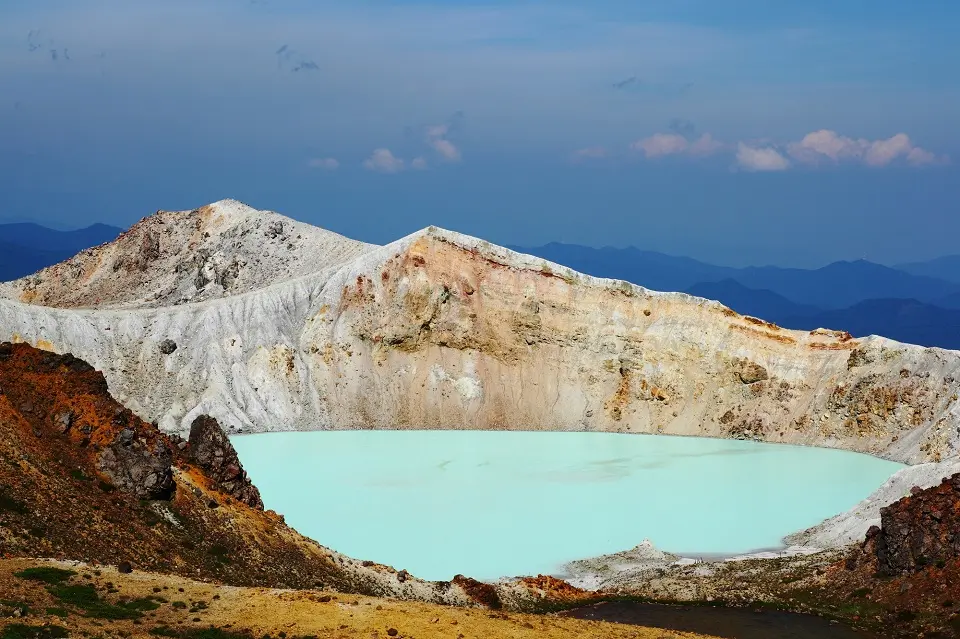
About Mount Kusatsu-Shirane
- Location and Overview: Mount Kusatsu-Shirane is an active stratovolcano located in Gunma Prefecture in the Kusatsu-Shirane Volcano group of Honshu, the largest island in Japan. It’s famous for its beautiful emerald-green crater lake, named Yugama.
- Significance: Mount Kusatsu-Shirane is one of the most active volcanoes in Japan and a popular destination for tourists who come to enjoy its unique volcanic features and surrounding hot springs.
- The Hiking Experience: Mount Kusatsu-Shirane’s landscapes are characterized by sharp volcanic peaks, picturesque lakes, and alpine plant life, offering a unique hiking experience.
Specific Inputs for Hiking in Mount Kusatsu-Shirane
- Hiking Trails: Several routes, varying in difficulty, are available for hikers. Some trails lead to the summit, while others take you around the beautiful Yugama Crater Lake.
- Attractions: In addition to the gorgeous views from the summit and the spectacular Yugama Crater Lake, the mountain is near the famous Kusatsu Onsen, one of Japan’s most famous hot spring resorts.
Tips for Hiking in Mount Kusatsu-Shirane
- Best Time to Visit: The best time for hiking is between May and November. However, due to the volcano’s activity, the trails and areas around the mountain might get closed periodically.
- Transportation: Buses run from Kusatsu Onsen to Shirane Kazan, a good starting point for the hike.
- Facilities: There are no specific facilities on the mountain, so carry everything you need for the hike.
- Precautions: Because the mountain is an active volcano, you should check the current volcanic alert level before planning your hike. The Japan Meteorological Agency regularly updates this information.
Mount Kusatsu-Shirane offers a unique hiking experience with its active volcanic landscapes and the stunning Yugama Crater Lake. A hike on this mountain can be truly remarkable, coupled with a relaxing dip in the nearby Kusatsu Onsen.
Hiking in Mount Tanigawa (Gumma and Niigata)
About Mount Tanigawa
- Location and Overview: Mount Tanigawa, or Tanigawa-dake, is between Gunma and Niigata Prefectures in Japan. Its jagged ridges and rugged appearance have earned it the nickname of “the roof of Japan.”
- Significance: While the mountain is famous for its natural beauty, it also has a notorious reputation due to the high number of accidents that have occurred there. Mount Tanigawa has a higher number of fatalities than Mount Everest, mainly due to harsh weather conditions, steep cliffs, and avalanches.
- The Hiking Experience: Despite its dangers, Mount Tanigawa offers breathtaking scenery, beautiful alpine plants, and a variety of hiking trails that attract hikers from all over the country.
Specific Inputs for Hiking in Mount Tanigawa
- Hiking Trails: The most common trail starts from Tenjin Ridge, which is easily accessible by the Tanigawa Ropeway. This route offers panoramic views of the surrounding area. Another popular but more challenging route is via Ichinokurasawa, a spectacular gorge known for its beautiful autumn colors and vertical cliffs.
- Attractions: In addition to the stunning views from the summit, the beautiful Ichinokurasawa Gorge, the winter snow-covered landscapes, and the Tenjindaira Ski Resort are key attractions for visitors.
Tips for Hiking in Mount Tanigawa
- Best Time to Visit: The mountain is accessible for hiking from late April to November. The autumn season is particularly popular due to the beautiful fall colors in the Ichinokurasawa Gorge.
- Transportation: The trailhead is accessible from the Doai and Minakami Stations on the JR Joetsu Line. You can also take the Tanigawa Ropeway from the foot of the mountain to the Tenjin Ridge.
- Facilities: There are mountain huts available on the trails where you can rest or stay overnight.
- Precautions: Given the mountain’s notorious reputation, it’s important to thoroughly prepare for the hike, check the weather forecast, and ensure you have the appropriate gear. Despite the risks, hiking on Mount Tanigawa can be an incredible experience with the right preparation and caution.
Mount Tanigawa’s rugged beauty and the thrill of its challenging trails make it a must-visit for adventurous hikers. It’s a place where one can fully experience the majesty and might of nature.
Hiking in Mount Nasudake (Tochigi)
About Mount Nasudake
- Location and Overview: Mount Nasudake, also known as Nasu-dake, is an active stratovolcano located in Tochigi Prefecture in the northern Kantō region of Japan. It’s part of Nikko National Park, the most famous of the Nasu volcanic group.
- Significance: Mount Nasudake is a popular destination for hikers and tourists. Its sulfuric vents, volcanic landscapes, and rich history and legends make it unique.
- The Hiking Experience: The mountain provides diverse hiking experiences, combining vibrant autumn colors, refreshing greenery in summer, and snow-covered landscapes in winter.
Specific Inputs for Hiking in Mount Nasudake
- Hiking Trails: There are a number of hiking trails on the mountain, but the most popular one starts at the upper station of the Nasu Ropeway, leading to the peak of Chausu, the highest point of Nasu-dake. The trail goes through volcanic landscapes, offering stunning views of the surrounding area.
- Attractions: In addition to hiking, you can enjoy the Nasu Ropeway for panoramic views, visit the famous Nasu Onsen Sanroku Tourist Center, or try the local cuisine at various mountain huts and eateries.
Tips for Hiking in Mount Nasudake
- Best Time to Visit: There are no restrictions on the timing; however, the best time to visit would be from late April to November. The autumn season is particularly beautiful as the foliage changes to brilliant red, orange, and yellow hues.
- Transportation: Access to the mountain is relatively easy, with good public transportation options. Buses are available from Nasushiobara Station to the base of the Nasu Ropeway.
- Facilities: The trail includes a few mountain huts where hikers can rest. Near the ropeway station, restaurants and souvenir shops are also available.
- Precautions: As always, it’s important to check the weather forecast and be adequately prepared. The sulfuric gas near the peak can be overwhelming, so sensitive individuals should take care.
Mount Nasudake’s combination of stunning volcanic landscapes and convenient facilities make it an enjoyable destination for hikers. It’s a remarkable location to appreciate Japan’s volcanic geology and natural beauty.
Hiking in Mount Norikura (Gifu and Nagano)
About Mount Norikura
- Location and Overview: Mount Norikura, or Norikura-dake, is at central Japan’s border of Gifu and Nagano Prefectures. It is part of the Hida Mountains, also known as the Northern Alps of Japan.
- Significance: Known for its accessibility and beauty, Mount Norikura is one of the most popular hiking destinations in Japan. The mountain is also filled with hot springs, waterfalls, and wildlife, making it an attractive location for nature enthusiasts.
- The Hiking Experience: From the peak, hikers enjoy stunning views of the Japanese Alps and surrounding landscape. The area is also famous for its beautiful alpine flora and fauna.
Specific Inputs for Hiking in Mount Norikura
- Hiking Trails: Mount Norikura offers a variety of trails for all levels of hikers. The most popular trail starts from the Norikura Tourist Center and leads to the peak of Mount Norikura. The trail is well-maintained and marked, making it easy for hikers to navigate.
- Attractions: Key attractions of Mount Norikura include the stunning Norikura Kogen highlands, the beautiful Sanbondaki Waterfall, and the stunning views from the Kengamine Peak, the highest point on the mountain.
Tips for Hiking in Mount Norikura
- Best Time to Visit: The best time to hike Mount Norikura is from June to October when the weather is relatively mild, and the alpine flowers are in full bloom.
- Transportation: The mountain is accessible by bus from the towns of Takayama, Matsumoto, and Shin-Shimashima Station. From late May to late October, a bus service operates up to the Tatamidaira area, near the mountain’s peak, making it one of the most easily accessible high mountains in Japan.
- Facilities: Several mountain huts along the trails offer rest or overnight stays. In the Norikura Kogen highland area, several accommodation options, hot springs, and dining options are available.
- Precautions: It’s important to check the weather forecast to prepare adequately. The weather can change quickly at higher elevations, so appropriate clothing and gear are necessary.
Mount Norikura’s natural beauty, variety of hiking trails, and easily accessible high peaks make it an ideal destination for hikers of all levels. The mountain offers an excellent opportunity to appreciate Japan’s alpine scenery.
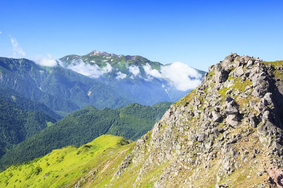
Hiking in Mount Hakusan (Ishikawa and Gifu)

About Mount Hakusan
- Location and Overview: Mount Hakusan, also known as the “White Mountain,” is located on the western coast of central Japan, straddling the borders of Ishikawa and Gifu Prefectures. Along with Mount Tate and Mount Fuji, it’s one of Japan’s “Three Holy Mountains,” and it’s an important spiritual symbol, especially for followers of Shugendo, an ancient Japanese religion.
- Significance: Mount Hakusan is home to various plant species and is a habitat for many animals, including the Japanese serow, a special natural monument. The area has been designated a national park (Hakusan National Park) to protect its unique ecosystem.
- The Hiking Experience: The mountain’s natural beauty and diverse landscape provide a rewarding hiking experience. During the summer, hikers can enjoy wildflowers, lush greenery, and vibrant foliage in the autumn.
Specific Inputs for Hiking in Mount Hakusan
- Hiking Trails: There are several routes up Mount Hakusan, but the most popular is the Saboshindo trail. It begins at Bettodeai, the last point accessible by bus, and it takes about 8-10 hours to reach the summit and return.
- Attractions: The mountain offers a variety of natural attractions, such as beautiful alpine flowers, picturesque landscapes, and the serene Hakusan Shrine at the base. From the peak, hikers can enjoy panoramic views of the Sea of Japan and the surrounding mountains.
Tips for Hiking in Mount Hakusan
- Best Time to Visit: The official climbing season is from June 1 to October 15. The peak is covered in snow for most of the year and is generally only snow-free during these months.
- Transportation: Access to the mountain is usually through Kanazawa or Hakusan City. Buses run from these cities to the trailhead at Bettodeai.
- Facilities: There are several mountain huts along the trail where you can rest or stay overnight. It’s recommended to book in advance during the peak season.
- Precautions: While the trails are well-marked, the weather can change quickly, and it’s important to be adequately prepared. You’re also advised to check the local forecasts before you depart and inform someone of your hiking plans.
Mount Hakusan’s spiritual significance, ecological diversity, and stunning views make it a must-visit for nature enthusiasts and spiritual seekers. The hike offers an immersive experience in one of Japan’s most revered natural landscapes.
Hiking in Mount Unzen (Nagasaki)
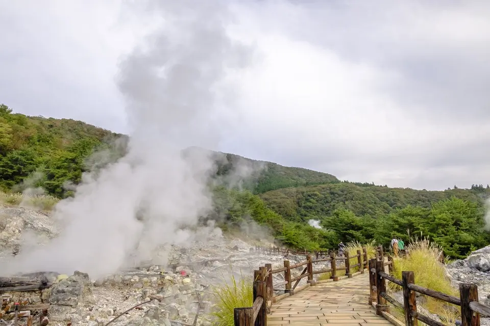
About Mount Unzen
- Location and Overview: Mount Unzen is located on the Shimabara Peninsula in Nagasaki Prefecture, in the Kyushu region of Japan. It’s an active volcanic group of several overlapping stratovolcanoes near the city of Shimabara.
- Significance: The Mount Unzen volcanic area has been historically active, with significant eruptions recorded in the past. Today, it offers hikers a unique experience due to its volcanic landscape, hot springs, and spectacular views.
- The Hiking Experience: Hiking at Mount Unzen provides an unusual experience, thanks to the unique volcanic landscape. Trails lead through lush forests and along craggy volcanic peaks, offering stunning views.
Specific Inputs for Hiking in Mount Unzen
- Hiking Trails: Trails to the summit of Mount Unzen’s highest peak, Fugendake, are well-maintained and clearly marked. The Nita Pass route is the most common starting point. From there, it takes about 3 hours to reach the summit. The trail is moderately challenging and may require some rock scrambling near the summit.
- Attractions: The primary attraction is volcanic activity, visible in steaming vents and sulfur deposits. The views from the summit are spectacular, overlooking the Shimabara Peninsula and Ariake Sea. Another attraction is Unzen Onsen, a hot spring resort town at the volcano’s base.
Tips for Hiking in Mount Unzen
- Best Time to Visit: The best time to hike Mount Unzen is from late April to November. Snow can make the trails challenging in the winter.
- Transportation: Shimabara Railway connects Shimabara City with Isahaya Station, from where JR and express trains link to Nagasaki and Fukuoka.
- Facilities: There are accommodations, restaurants, and hot springs in Unzen Onsen town.
- Precautions: As Mount Unzen is an active volcano, it’s crucial to check for any volcanic activity advisories before you hike. Also, the weather at the summit can be much colder than at the base, so appropriate clothing and gear are necessary.
Mount Unzen offers a unique hiking experience with stunning volcanic landscapes and fantastic views. Coupled with the nearby hot springs town, it provides an excellent combination of adventure and relaxation.
Hiking in Mount Aso (Kumamoto, Kyushu)
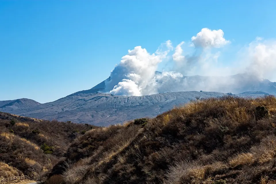
About Mount Aso
- Location and Overview: Mount Aso is located in Aso Kuju National Park in the Kumamoto Prefecture, Kyushu Island, Japan. It’s one of the world’s largest calderas, and within this gigantic caldera, there are five individual volcanic peaks, collectively known as Aso Five Peaks (Aso Gogaku).
- Significance: Mount Aso is known for its active Nakadake crater, one of the most active volcanoes in Japan. On non-active days, the crater often belches out smoke and has an attractive, emerald-green volcanic lake.
- The Hiking Experience: Hiking at Mount Aso provides a unique and exciting experience, thanks to the volcanic landscape. The peaks offer panoramic views and the opportunity to see an active volcanic crater up close.
Specific Inputs for Hiking in Mount Aso
- Hiking Trails: There are various hiking routes around Mount Aso. One of the popular ones is the trail around the Komezuka volcanic cone and Kusasenri-ga-Hama field. Please note that the trail to the Nakadake crater is often closed due to volcanic activity. Always check the current status on the official website or local tourist information center.
- Attractions: Besides the scenic trails, the major attraction is the Nakadake Crater. When the volcanic activity is low, you can even take a ropeway or drive up close to the crater. The surrounding Aso region also boasts beautiful rural landscapes and hot springs.
Tips for Hiking in Mount Aso
- Best Time to Visit: The best time to hike Mount Aso is from late March to November. However, access to the Nakadake crater is highly dependent on volcanic activity.
- Transportation: JR Aso Station is the gateway to Mount Aso, with train connections from Kumamoto and Beppu.
- Facilities: The Aso region, including Aso City and the nearby Kurokawa Onsen area, offers various accommodations, restaurants, and hot spring facilities.
- Precautions: Given the volcano’s active status, always check the latest information on volcanic activity and trail closures. Depending on the volcano’s current condition, safety gear, like a gas mask, could be necessary.
Mount Aso offers a remarkable experience with its unique volcanic landscape and diverse outdoor activities. Just remember to consider the volcano’s activity when planning your visit.
Hiking in Kuju Mountain (Oita and Kumamoto, Kyushu)
About the Kuju Mountain Range
- Location and Overview: The Kuju Mountain Range is situated in the eastern part of Kyushu Island, in Oita and Kumamoto Prefectures, Japan. It forms the central part of the Aso-Kuju National Park, the first national park designated on Kyushu Island.
- Significance: The Kuju Mountains are the highest mountains on Kyushu Island. The range includes several peaks, the tallest of which is Mount Nakadake, at 1,791 meters.
Specific Inputs for Hiking in the Kuju Mountain Range
- Hiking Trails: Multiple trails traverse the Kuju Mountain Range, providing various hiking experiences to cater to different fitness levels and time frames. One of the most popular routes is the trail from the Makinoto Pass to Mount Nakadake and Mount Mimata, which typically takes around 4-5 hours to complete.
- Attractions: Besides the breathtaking views from the highest peaks, the Kuju Mountains are known for their rich flora and fauna. Depending on the season, hikers might come across fields of wildflowers, including the Miyama Kirishima (a type of azalea) that paints the mountains pink in the spring. Other attractions in the area include hot springs and the Kuju Flower Park.
Tips for Hiking in the Kuju Mountain Range
- Best Time to Visit: You can go hiking in the Kuju Mountains all year round, but the scenery is especially stunning during the spring wildflower season and autumn when the leaves change colors. Be mindful that the weather can change rapidly at higher elevations, so prepare accordingly.
- Transportation: Access to the Kuju Mountain Range is usually through the cities of Beppu or Oita, which are connected to the rest of Japan by the Kyushu Shinkansen. From there, local buses run to the main trailheads.
- Facilities: The Makinoto Pass, a common starting point for hikes, has restrooms and parking. Several ryokans (traditional Japanese inns) and hot springs are located in nearby towns, providing comfortable places to rest and relax after a day of hiking.
- Precautions: As with any mountain hike, it’s important to check the weather forecast before setting out, wear appropriate clothing and footwear, and ensure you have enough water and food supplies.
Hiking in the Kuju Mountain Range provides a great opportunity to appreciate the natural beauty of Kyushu Island. This destination offers thrilling trails for hiking enthusiasts, rich biodiversity, and soothing hot springs for relaxation.
Final Words about Hiking Experiences in Japan
Embarking on a hiking adventure across Japan, you’ve encountered many experiences beyond just beautiful landscapes. Each trail has offered unique insights into the culture and history of this remarkable country. Whether it was Mount Fuji’s challenging heights, the Kumano Kodo’s tranquil paths, or the charming rural landscapes of the Nakasendo route, each journey has given you a deeper understanding of Japan beyond its cities and towns.
As you finish your final hike, the memories of these journeys will remain with you. You’ve not just explored the mountains, forests, and coasts of Japan, but you’ve also experienced the country’s cultural heart. These experiences offer a glimpse into the Japanese love and respect for nature, which is deeply intertwined with their daily lives.
So, even as your hiking adventure comes to an end, remember that Japan is a country of endless discovery, with many more trails to explore. With every return, you can look forward to new experiences and further understanding of this fascinating country. Hiking in Japan isn’t just about outdoor exploration but about connecting with a place and its people, one step at a time.
(picture credit: Japan National Tourism Organization)

A long-term ex-pat in Japan, Himanshu comes with an IT background in SAP consulting, IT Business Development, and then running the country operations of an IT consulting multinational. Himanshu is the co-founder and Managing Director of ReachExt K.K. and EJable.com. He is also an Advisory Board Member of a Silicon Valley AI/IoT startup.
For any queries, comments, or suggestions, Himanshu can be contacted by email @ [email protected].